Disclosure: I may earn affiliate revenue or commissions if you purchase products from links on my website.
Promotion: I wrote Framed: A Villain's Perspective on Social Media. It's an outgrowth of everything visitors have liked about this blog since 2016. It's now on sale for $3.99!
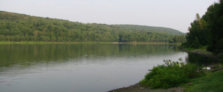
Continuing my exploration of places to run in Northeastern Pennsylvania, I was surprised when I found out about Prompton State Park. It’s about the same driving distance from my home as Lackawanna State Park. Twenty-six miles of trails surround a 290-acre lake. On paper, it looks like a viable alternative to Lackawanna State Park, which my buddies and I have run so often that we simply refer to it as the state park.
Though the parkland has potential, Prompton State Park is “undeveloped.” Many segments of trail that would be ambitious for casual hikers to reach were poorly maintained with high weeds, low trees, dense thickets, and, at times, no markings. For an eight-mile-long trail run in the early Spring, running the path closest to the lake is something I’d attempt once or twice per season. But, in its current state, going into the backwoods in the mid-summer is not something I’d recommend. There are some beautiful wilderness features and drastic changes to the scenery as you move through different elevations, but it’s going to be a rough, technical, itchy, low-cadence affair for most trail runners.
My first run at Prompton was 9.8 miles. You can follow my route here.
Where to Start
I think it’s natural to start your run at the southwest corner of the park from one of the lots marked for trails/disc golf. We started by running counterclockwise over the dam. Since there are so few other access points, this is probably the best place to be. If you’re not looking to lap the lake, you can park in the north lot off Beech Grove Road for easier access to most of the trail network.
East-West Lake Shore Trail Over the Dam
Since this is a connecting trail less than a half-mile long, I don’t know what to call it. The West Lakeshore Trail ends at the north end of the south parking lot, and the East Lakeshore Trail begins on the east side of the dam. If you want to run the full circumference of the lake, you have to cross the dam. Once you ascend the paved path from the parking lot, which looks like it might be a dead-end, you enter the dam’s path through a doorway. It’s a crushed stone path providing the last opportunity you’ll have to run fast.
Hemlock Trail
Immediately after crossing the dam, you’ll encounter your first confusing choice. There’s a path between some fallen trees that goes in the direction of the Hemlock trail. There’s a better-tracked path to the left which is presumably the East Lake Shore path. Not wanting to make a wrong turn, we powered through the rough clearing and soon found ourselves at a junction indicating which way was the Hemlock Trail and which direction followed the lake.
The Hemlock Trail starts with a steady climb. It’s fairly rocky and slippery with some switchbacks, but being in a cool dense forest makes up for it. As you start to crest the hill as the first mile ends, there is a lot of dense vegetation. Unfortunately, this includes picker bushes. It’s difficult to see where you’re going and maintain anything more than a trot.
You will be presented with several options to drop onto the Bone Ridge Trail, which I don’t recommend just because it’s a loop that doesn’t really take you anywhere. It will make it easy for you to lose your sense of direction if it’s your first time running here.
As you descend from the high point, you will be presented with a fork in the Hemlock trail. We tried to follow the northeasternmost fork, knowing that it would maximize distance, but it has been reclaimed by nature. We couldn’t follow it, so we turned around and took the lower fork (which is the only one that appears on the official map). Even though we had a few dry days, we encountered a lot of mud here.
Not much more than a quarter-mile later, we arrived at a stone slab in the middle of the woods. According to the Strava trail map, several trails converge here. The markings were scarce, so we took what looked like the most worn trail which brought us in a tight loop to a lower part of the trail. In doing this, we missed the High Ledge Trail entirely and found ourselves on something else that was unmarked.
Lower High Ledge Trail
No longer being on the Hemlock trail and being too low to follow the High Ledge Trail, I am naming this trail the Lower High Ledge Trail. Almost immediately, we found ourselves in a small alpine meadow where we lost the trail again. We retraced our steps and found stones placed over a log to accommodate bikers, so we followed that path and picked up the trail again. We navigated this path by finding fallen trees that had been cut through. This was a fun part of the run, though muddy in parts and with tall weeds in others.
There was a portion of this trail where we descended next to a perfectly-cut rock ledge. I really liked that.
Sugar Shack North Trail
Before long, we had linked onto the Sugar Shack North Trail. This was expected, but I started to become disoriented because there was no signage at all. This trail featured some dense thickets, mud, and weeds. It was not in good condition to run on. What added to my confusion was that as we lost elevation and crossed a mountain stream (visible on Strava), there was a sign directing us to Sugar Shack South Trail or Sugar Shack North Trail. I didn’t understand this because the “South” Trail, assuming that meant “Sugar Shack North Trail Heading South,” should have been the path we were already on. We headed north, climbed a mountain again, and no sugar shacks were spotted.
Eagle Pass Trail
The name Eagle Pass does confer the idea of wide-open space, maybe the first peek at the lake or countryside. It was simply a trail with a higher elevation.
Runoff Trail
Here’s where the run was most negatively affected by inconsistent signage. We reached a junction where the Eagle Pass Trail met the Cross Trail. We were baffled because none of the maps we memorized mentioned the Cross Trail. Unfortunately, there’s an error in the map provided by the DCNR. The Eagle Pass Trail is supposed to run directly into 3 other trails: Pine Creek, Sidewinder, and Cliff. The last segment of it is actually the Cross Trail. This threw us off and we instead followed arrows on the trees down what appeared to be a riverbed.
This was the worst part of the run, just a straight downhill where we were basically walking over all types of hazards. At the bottom, there was a picnic table, and after trodding through some waist-high weeds, we found where the East Shore Trail met the Sidewinder Trail.
Upper East Shore Trail
The upper portion of the East Shore Trail is really nice, though without much of a view of the lake. It starts off in some swampy grassland and then enters a paved portion. Usually I hate encountering paved portions, but this was welcome after spending so long in the woods. You’ll pass by the Hiker Trail entrance and other things that are not marked on the official map.
Beech Grove Road – Route 170
For a brief amount of time, you’ll have to pop out onto Beech Grove Road, take a turn, and run in parallel with the state route. As soon as you see a gravel path leading to what seems like nowhere, head down it. Now you’re on the west side of the lake.
Flyers Field
Connecting to the West Shore Trail, you’ll pass through Flyers Field. I think this is for model airplanes and the like. I just wanted to mention it because the field was the nicest manicured lawn I have ever seen in my life. Through some tall weeds, it connects to the West Shore Trail.
West Shore Trail
Running the length of the West Shore Trail is not as family-friendly as the name would suggest. There are a lot of small streams you’ll have to cross over. The whole thing is rocky, rooty, narrow, and technical. The trail map suggests that it’s a straight shot, but this isn’t the case. It meanders quite a bit, adding on what is probably a little less than a half-mile. My legs were exhausted at this point.
This was still fun to run and is a sane trail to approach as a trail running. Not much room for error and easy to trip and fall, but it wasn’t bad. About two miles in, you need to cross a road to the boat launch parking lot. At this point, I’d recommend heading up to the Orchard Trail or just finishing your run on the road. My legs really took a beating on the last two miles.
Summary
With enough bushwacking and an updated map, this would be a fun, challenging trail network for long runs. I had a worthwhile adventure, but I don’t think a mainstream trail runner or mountain biker would enjoy it all that much.