Disclosure: I may earn affiliate revenue or commissions if you purchase products from links on my website.
Promotion: I wrote Framed: A Villain's Perspective on Social Media. It's an outgrowth of everything visitors have liked about this blog since 2016. It's now on sale for $3.99!
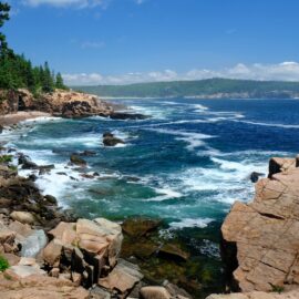
Having little contact with other humans over the last few months allowed me ample time to start running again. I just finished my first 40+ mile week since 2015 and capped it off with a run at Salt Springs State Park here in the Endless Mountains in Northeastern Pennsylvania.
There is a growing running scene on Youtube (thanks, Nick Symmonds & Tinman), but that type of content doesn’t really help people find the best runs in any given area. Nobody really takes the time to write or produce videos about these things, and my experience has been that websites providing basic information rarely cater to runners.
In the past–when I was logging most of my lifetime mileage–it was difficult to find new places to run. Here in Scranton, PA, you could spend a lifetime searching and still not make much headway. Pennsylvania is one of the most beautiful states in the country and Scranton is the gateway to a vast wilderness & state park system, but most runners I know aren’t particularly well versed in what the area has to offer.
I recently relocated from Chicago to Scranton, and the first thing I did was hit the trails. When doing some research, I learned about Salt Springs State Park near the NY border. I decided it would be a nice place to take my parents, especially since their anniversary and Father’s Day ended up being on the same day. It was about an hour away from Scranton, wrong turns included.
The Run
My run at Salt Springs State Park was one of the most enjoyable I’ve experienced. It being my first time, the run was rife with challenges, but overall things turned out quite well. This is my first time writing about running, aside from my college essay, so I’m just going to get into it. You can follow along with my run here.
The Gorge Trail
I started on the Gorge Trail from the mouth of the parking lot. The initial ascent was steep but my parents were still watching at that point so I had to make some effort. There was a rope alongside the first part of the slope and my GPS says I gained 100ft in elevation pretty much immediately. The trail flattens but remains rough, and the view of the gorge from this side of the waterway is unexciting, compared to something like Nay Aug Park. I briefly went through a meadow before spilling out onto Buckley road, just under .5 miles in. Overall, this wasn’t something I would ever run again.
From Buckley road, I knew I had to hop in on the other side of Fall Brook, but there were no markings. Appreciating the dirt road, I ran to the nearest trailhead (which ended up being the Bunny Trail) where I found a map. There were no paper maps, due to the virus, so I tried to memorize it as best as I could.
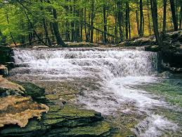
Fall Brook Trail
I picked up the Fall Brook Trail by hopping over a guardrail marked with red blazes. The entryway was easy to miss, especially since the trail was very narrow with high grass and weeds–an ideal tick habitat. Before long, it opened up, and after hopping a creekbed I was able to decide to continue along the Fall Brook Trail, a route people seemed to take when they were interested in the water, and the Hemlock Trail. The Hemlock trail struck me as the focal point of the park, so I ascended once again. Here, I was running in parallel with the Gorge Trail, just on the other side of the brook.
Hemlock Trail
The Hemlock Trail looks like it belongs in the Pacific Northwest. The beauty of the tall hemlock trees towering over the slick wooden walkway is picture-perfect. Accounting for the Bunny Trail detour, I completed the first mile of my run once I made it to the hemlocks. It is tempting to run quickly once you make it to this surface, which will certainly scare the shit out of other people. For those looking to meander through, there is an overlook that provides a much better vantage point than anywhere on the Gorge Trail. Doesn’t hold up to Nay Aug Park–but it’s a special place.
Descending the Hemlock Trail to the main parking lot can be very fun for the aggressive trail runner. The path widens and has elongated tiered steps bordered by young logs. Nobody is going to expect a runner here, but you can fly down the hill even in light traffic.
Back in the main area, I almost exited the park and attempted to access a trailhead in the camping area. It turned out that that wasn’t where the trail was, but a nice woman let me peer at her map, which I tried to commit to memory again. Finding myself back at the base of the Hemlock Trail (where it meets the Fall Brook trail and–as it turns out–the Hardwood Trail), I was at about 2 miles. I had no idea what I was in for.
Hardwood Trail
I started the narrow path to the Hardwood trail, which led to the Upland Trail. I selected this trail because it wrapped around most of the area of the park, so I’d be able to get in plenty of distance. In the first quarter-mile, I gained about 100ft of elevation. Not having run any hills in Chicago, I was already pretty beat up, but I pressed forward. Wanting to go to the extreme border of the park, I missed a turn to get onto the Upland trail and went about 50m down a Logging Road. Not a big deal. I turned around and proceeded onto the Upland Trail.
Upland Trail
Over the next 600m, in a very cool and peaceful forest, I gained another 200ft of elevation. The grade was so steep that I was on my toes for it. I would go as far as classifying the place as a no-fall zone. If I had to ski down it, I’d be frightened. I hit my maximum heart rate on the run–182bpm–while on the steepest grade just before the summit–40%.
Not even three miles in, I had run most of the strength out of my legs. There was a gentle downhill that then led me to a crossroads. I selected the Friends Trail, knowing that it would take me wide. But first, to summarize. The Upland trail was absolutely gnarley to run on. There were points in my life where I would have taken a heart attack had I tried to run on this.
Friends Trail
Onto the Friends Trail, things changed dramatically. I found myself in a lush, freshly-mowed meadow. It was a little damp, and man, was it humid. It was almost like a video game. I couldn’t believe the natural beauty that I had been sorely missing living in an urban area. As I continued running, I heard (wild?) dogs barking, which did kind of scare me.
Onto my fourth mile, I was crossing Buckley Road again (I didn’t realize this) onto the continuation of the Friend’s Trail. Now I was in a low-lying marshland with tall grass and a very narrow path, not dissimilar to the entrance to the Brook Trail. Things opened up slightly but it was still obvious that this trail wasn’t well-tracked compared to the ones in the official State Park land. I passed the sign for the Friend’s parking lot, and decided to continue on the trail.
The trail was really well maintained and the slope was gradual, but I still gained 400ft in just over a mile. Where the Friends Trail breaks into the two branches of the Summit Trail, I was tired and wanted to get back, so I stupidly avoided the final short climb to the summit. Not sure if there would have been a crowd there waiting for me like in the Tour de France but damn, that would have been nice to see.
The Friend’s Trail was incredible. Just an ideal slice of Pennslyvania wilderness and a massive elevation gain.
Cliff Trail / Cliff & Summit Trail
I took the Cliff Trail to the Cliff & Summit Trail, which was disorienting. I wanted to head north and ever-so-slightly west, knowing there were other easier trails to link up with. However, I became disoriented, and this downward slope took me to my southernmost point yet–the Frog Pond.
I stopped for a few moments to hang out at the Frog Pond. It was nice to see the signage and realize that this must have been a “furthest point” of some type. I proceeded back up the Summit Trail, but the slope was steep and I looked down at my watch and realized I had already been running for almost one hour. What scared me the most was that a huge amount of this effort was spent moving duly south from the parking lot. I turned around and moved onto the Cliff Trail.
Bunny Trail
The Cliff Trail intersected the Bunny Trail and I choose the way that I thought was more logical (it was) but it ended up being slightly longer. I ripped down the trail until I heard water and saw people before exiting onto the Bunny trailhead on Buckley Road, where I had first stopped. With no easy way back, I then passed through the hemlocks again to the main parking lot
It was a massive run. This park, with 700 acres, has some of the most fun trails I have ever encountered in my life. I will remember my day here forever.