Disclosure: I may earn affiliate revenue or commissions if you purchase products from links on my website.
Promotion: I wrote Framed: A Villain's Perspective on Social Media. It's an outgrowth of everything visitors have liked about this blog since 2016. It's now on sale for $3.99!
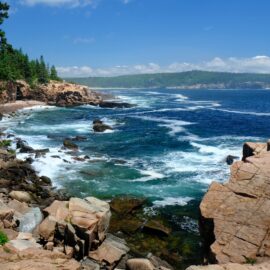
Earlier this spring, I decided I would spend a month or two in Flagstaff, Arizona. The town is at 7000′ of elevation and the surrounding area is considered both a running mecca and an ideal location from which you can stage day trips to outdoorsy places. Before I was forced to drag myself back into the office in Chicago, I wanted to get in some serious mileage. I even convinced one of my high school teammates to join me. As of today, my body is completely broken down, and I doubt I’ll be scoping out any new runs. I’ve decided to share my knowledge while it’s still fresh. Though Strava links are eternal.
While there are many well-known runs around Flagstaff, it’s surprisingly difficult to scratch the surface of what the area has to offer without trawling Strava. Many of our routes involved Strava research, AllTrails comparisons, searching through Forest Service info pages, and visualizing the trailheads using Google Street View. We don’t run with cell phones, and almost every time we skimped on this pre-run investigation, it came back to bite us.
It’s not that trails are hard to find. It’s surprisingly difficult to grasp trail conditions, understand navigatable landmarks, prepare for the unknown, and, generally, to make the most of your time in Flagstaff. I want to take out some of the guesswork. Running is a demanding sport–if you’re only visiting for a week and have two mediocre runs and make one really wrong turn, those are costly mistakes. I hope my commentary and suggestions for routes can help make Flagstaff an even better place for runners.
A1 Mountain Loop
Among the most legendary routes in Flagstaff, the 20.8 mile A1 Mountain Loop has pretty much nothing to do with the nearby A1 Mountain. There’s an in-depth article, probably the most thorough “Strava Segment” story that has ever been produced by a primary news source, which I’d highly recommend reading: Outdoors: Running for (virtual) records on the A1 Mountain Loop.
I’m getting paywalled by the AZ Daily Sun now, but I do clearly remember that the net elevation stated in the article is completely wrong. The author claims something like 2900′ feet of climbing when in actuality it’s just over 1000.
For the segment, you turn off A1 Mountain road and park on the shoulder. There appeared to be a porta-potty in the nice development set back another quarter mile, but otherwise, there are no facilities at all. You run Forest Road 518 for 7 miles before turning left at the fork and looping a little over six miles around Wing Mountain. This involves taking 222A to 222 (unmarked but obvious) then 222 to 519 which takes you back to the 7-mile “stick” of the lollipop.
I happened to encounter a few top-tier American pros as I struggled through my last few miles here–there is no question that it’s a popular training spot. However, is it worth driving 15+ minutes outside of town if you’re not going to complete the route and will use it as an out-and-back? Meh, there’s a reason I saved it for last.
A1 has a lot going for it. The frequent but rarely severe elevation changes add up as you tick off mileage. There’s maybe one stretch around mile 13 that could be considered brutal, but the rest (mile 18? mile 20?) will be relative to your effort. You have something resembling shade for most of the course, and only a few miles completely exposed to the sun. You also have a perfectly spaced fueling stop at the intersection of 518 and 519 (mile 7, mile ~13). We drove out earlier in the day to drop off supplies and that was crucial to our finishing the run.
The surface is a wide well-traveled dirt path with a lot of little rocks.
Wing Mountain Loop
For all intents and purposes, A1 Loop is actually a Wing Mountain loop with a longer, alternative lead-in. Before we knew this, we parked at the start of FR 222 and attempted the counter-clockwise variant of the Wing Mountain portion of the A1 loop. This run is excellent. It gives you a taste of A1 without requiring you to commit to massive mileage. The lead-in is only about 1.5 miles and, if you do it correctly, the segment is roughly 10 miles total.
Accessing FR 222 requires driving northwest from Flagstaff for a little longer than if you were driving to A1 Mountain Road. What we didn’t like about this route was that it was easier to get lost, and get lost we did. 3.8 miles into this run, 222 splits to 222A (to the left) and (I think?) 317. 317 appears to be the better-tracked route, but you’re supposed to take a left onto 222A. This is the same junction that you’ll reach coming from the opposite direction doing the A1 segment, but since it’s such a subtle forking, you’d never think to turn left in the completely wrong direction on the way down. If you’re just doing Wing Mountain in the CCW direction, it’s easier to get confused. 317 is a passable, mellow route but it’s not going to bring you particularly close to anything you want to be near and doesn’t have much shade.
We ran Wing Mountain later in the morning, and there were a ton of vehicles using the road and kicking up dust. I’d recommend going earlier in the day.
Blue Dot
This is the… sketchiest… way to ascend Flagstaff’s flagship mountains. There’s very little information about Blue Dot online so I will gladly provide my experience. This is not a route that could be mountain biked. This is not a route that most fit people would enjoy hiking. You’ve got to be crazy to try to run it past the first quarter mile or so. Trying to take Blue Dot back down without specialized training or hiking equipment is even more dangerous than ascending it. Personally, I would never attempt it.
Blue Dot involves just under 2000′ of elevation gain over a single mile. If you try it, you will be walk-jogging up a mountain that features tough technical terrain, rock faces that will be dangerous to climb with non-specialized running shoes, and a final ascent involving the softest, loosest dirt that can be found on planet Earth.
I was exhausted when I reached the top. It took me about 40 minutes. The fastest known time is about 22 minutes, for perspective. Once you get to the top, again, I highly recommend that you have planned another way down. We took the Private Reserve Trail, which had much less extreme elevation changes, but which I still found to be dangerous while wearing what were essentially road racing shoes.
There will not be a sign informing you of the location of the Blue Dot trail. My advice is to hug the base of the mountain as you head north, somewhat in line with the Forces of Nature trail. You’ll know you’re in the right place when you see rocks painted with small blue dots. Note: these dots are genuine dots, much smaller than the red circles on nearby trees.
To follow the Blue Dot trail, you will need to follow the dots painted on rocks. Unfortunately, for long stretches of the trail, there are no dots at all. You just have to keep climbing with a preference for moving to the right, and you’ll eventually reach the top.
There is no direct way to access this trail. Most would be best off starting at Buffalo Park and proceeding straight 2-3 miles onto the Oldham Trail until it merges with Forces of Nature.
Buffalo Park
Buffalo Park is best used as a casual soft surface run. There are scenic views and several connections to the urban trail system and the Mt. Elden trail system. If we’re talking bang for your buck, the views are awesome, there are real restrooms, and you’ll feel fast while ripping around this park where Buffalos actually used to roam. Slight elevation changes will lead to sneakily quick splits if you decide to run a workout here, though the prevalence of pedestrians, curves, and dogs will make this difficult. The main loop is just about 3,000 meters.
There is a large parking lot here. Signage in the park is irrelevant, you’ll know where to go. There are also virtual runs you can find on Youtube to give you a better idea of the layout of the park.
FUTS / Route 66
The last few miles of this run followed Route 66
Since we live on the east side of town, we decided to try the Flagstaff Urban Trail System path which follows Route 66 from one side of town to the other. Running on the hard surface really bothered us, and while this might be useful for bike commuters, it can easily turn into a death march for runners. There is also at least one very long stoplight that you can’t avoid, plus some loud-ass trains.
Pipeline / Forces of Nature / Oldham (Elden base trails)
We had a direct route to the pipeline trail in our backyard, so we ended up running there often, even using it to connect to other routes including Fatman’s Loop, Buffalo Park, and Blue Dot. Though the pipeline trail is a Flagstaff classic, the biggest benefit is the convenience it offers as a thruway. There are a few fast segments, but also some huge hills and very loose rocks. People also love taking their dogs off their leashes on this trail.
The Forces of Nature trail is set back more close to the mountain. It’s a bit windier and technical and offers the benefit of increased shade. Oldham (upper, lower) is a trail extending north from Buffalo park that traces the west side of Elden, before curling in and actually taking you up “the back way” to Elden. We never took it all the way, as the portion of the trail north of Elden was pretty crummy to run on.
These trails are all good but we mainly used them to connect from one destination to another. There are much smoother routes you can take if you really want to get a workout in.
Mt. Elden Lookout Trail / Fatman’s Loop
These are popular hiking trails that will mostly be enjoyed by more serious trail runners. The first portion of the Elden Lookout trail forms the first half of Fatman’s Loop. At the apex (in elevation) of Fatman’s/Elden Lookout, you can continue up to the top of Elden or continue on Fatman’s. To be fair, my 66-year-old parents didn’t have too much of a problem walking Fatman’s. However, when I broke away from them and tried to run up Elden, it was grueling.
Heading up Elden Lookout, the signs are helpful. The hike is both beautiful and straightforward. Heading down Fatman’s, the signs are pretty bad. There are a few insignificant meandering paths that will be frustrating your first time.
There is a parking lot here which is packed nearly every time I pass it.
Old Caves Crater Loop
Accessed from Silver Saddle road, we figured there was probably a good reason that this wasn’t a popular running path. The reason is that the path is almost entirely soft cinders which are really hard to run on. To make the most of this short loop, we first ascended the old volcano and enjoyed a nice view before descending and following a full loop around the crater/mountain.
This can be nice if you’re really looking for something different, but you’d be crazy to want to work this into a regular rotation.
Elden Springs Road
Across the street from Old Caves Crater, you have Elden Springs Road. This is a dirt road northeast of town that provides access to some exciting trails on the east side of the mountains. The elevation changes here are consistent and increasingly dramatic: 150′. 225′. 325′. We tried this pretty early during our time in Flagstaff and I found it to be really difficult and not rewarding at all. I still have a lot to learn about this road and the trails that branch off it.
Picture Canyon
Picture Canyon Preserve is a unique nature and cultural area just east of Flagstaff. It is most notable for the petroglyphs preserved inside the park. The full loop here is only about four miles and much of the surface is a cinder-like substance. It’s like running on black sand. It’s exhausting.
We extended a wee bit onto nearby dirt roads which passed a lot of angry dogs and led to a few dead ends. The only redeeming point on this run is that the Arizona Trail segment extending from the northwest corner of the park is some of the most beautiful singletrack trail I’ve encountered. As an added bonus, it includes a tunnel that takes you under Highway 89. Pretty neat but there’s not much to see here.
County Highway 394 / “About time somebody made a segment”
I have no idea how my buddy found this road. It’s pretty far outside of Flagstaff but people travel here to train. The surface material and width are comparable to Woody Mountain Road. It’s just that the setting is much more barren and you’re running in parallel with a real highway. It’s so desolate with a few rolling hills that it will remind you of a western movie cliche.
I’m imagining that this road is used by serious runners for predictable tempo runs. While thru traffic is going to be much lighter than Woody Mountain, you’re at the full mercy of the sun and wind here. The segment is 4.62 miles from the start of the dirt road to Angel Road. We extended a bit for ten even. My thought is that if you’re going to travel this far, you had better have something serious in mind.
Note that there did appear to be a portapotty after turning off the highway onto the paved portion of the road. We saw what appeared to be an entire family queued up to use it.
Campbell Mesa Trail System
Just past the duck pond at the country club, you have the Campbell Mesa Trail System. My opinion is that this is the trail system with the widest appeal in Flagstaff. You can run it, hike it, bike it, let your unleashed dog wreak havoc, anything goes here. The trails, while a bit narrow, are accessible for the whole family. I brought my parents here and they loved it. There are so many different loops you can do that it’s as easy to put together a 2-mile run as it is a 10-mile loop.
Toward the back end of the park, you’ll see that we made a wrong turn onto a trail that ran parallel with the Walnut Canyon Road. Make sure not to do that and you’ll be fine.
This is a very well-trafficked trail system but if you try to run the full Campbell Mesa Loop, be aware that your only companions will likely be mountain bikers.
Thorpe Park / Mars Hill / Flagstaff Mesa Trails
Loop starting at Thorpe Park
Starting at Thorpe Park, we ascended Mars Hill and turned onto FR 515C before descending onto the Tunnel Springs trail and then running a few miles through town. The initial climb was too much for me (400’+ over the first two miles) but once things level off, this is a nice run. It’s too bad that you can’t loop back around without ascending the mesa again. We just meandered through town and found our way back to Thorpe Park.
Forest Service Road 700
Many miles south of town near Kachina Village, you have FR 700. It’s a more challenging dirt road with two 100’+ climbs and quite a bit of sun exposure. It’s worth checking out if you need variety, but we were annoyed by the amount of traffic here, plenty of people in offroad vehicles taking laps and kicking up dirt. This is an extremely long road that will bring you as far south as Mormon Lake. We did not get that far.
O’Leary Peak / Forest Road 545A
This is the first run I’ve ever completed where I thought the entire route would be better suited for downhill skiing than running. O’Leary peak is a 10-mile out-and-back mountain run on Forest Road 545A. It’s unique because most people would associate 500′ gain per mile with winding, craggy, technical trails, but this is a plain old dirt road. The road is actually in great shape as it is likely for official use only. It ends up being a fitness test (with a flat first mile) that offers no excuses. Can you run it without stopping, at any pace? My answer: barely.
Many miles away from Flagstaff proper, the views from O’Leary Peak are gorgeous. With permission, you can ascend the fire tower at the top. My take is that there’s no point in doing this if you don’t think you can keep a steady cadence up the whole thing. You can easily hit a PR in your preferred distance on the way down.
Schultz Creek / Little Gnarly Trail / Dry Lake Hills Network
The Schultz Creek trailhead is due north of town and requires traveling down a steep dirt road into the main parking lot. The trail system back here is best suited for mountain bikers. I don’t know much about mountain biking but I’d think that this network could be considered world-class. You’ll encounter quite a few of our biker friends.
For the first 3.5 miles of this run, you’ll be running in parallel with Schultz Creek and the Schultz Pass Road. It feels quite remote but you’re never too far from a more mellow dirt road. This trail is technical with large elevation gains per mile, something like 150′, 200′, 200′, 250′, 350′. Once you arrive at the fork in Schultz Creek, there are signs for the Sunset Trail but not much else. Right around this point, the widest trail will take you up a mountain, so it can be quite frustrating if you don’t know exactly where you are.
We were tired and were losing daylight, so we turned around, just checking one other trail to see if it was the right one. Apparently, we ended up on a trail known as the “Little Gnarly Trail.” Gnarly indeed. We didn’t want to risk exhausting ourselves on the climb or actually getting lost. However, if we stayed the course for another half mile, we could have connected onto one of many trails which could have prolonged our journey or provided an option to loop back to the start. This network is poorly marked so I’d highly recommend bringing a map or keeping detailed notes in your pocket.
Lake Mary Road / Mailboxz
There are quite a few articles that mention running along Lake Mary Road. It’s a long road with what is, at times, a very wide shoulder. Based on driving it, it seems kind of dangerous and I don’t know why anyone would want to run there.
There are a few nice roads that you can run just off Lake Mary Road. The one that we found looped Crimson Road/FR 296(A). Don’t try to drive through the nearby campsite, as the road is rough and the gates are locked. There is nowhere to park here, so we just parked on the shoulder of the road.
We completely screwed up this run by not running it counter-clockwise and by ignoring the turn onto FR 296A. The road became rougher on the part we extended onto, and we ended up turning onto a dried lakebed which brought us back to Crimson Road. We had to flag down a car and ask for directions.
Anyway, this was a fun dirt road with one ridiculous uphill/downhill, depending on which direction you run. Here is the actual segment: https://www.strava.com/segments/11142986.
South Woody Mountain Road / Woody Mountain Road
Woody Mountain to Arboretum
Woody Mountain Long from Arboretum, Rogers Lake to Golf Club
South Woody Mountain Road is a classic and it was one of the routes I most looked forward to when moving to Flagstaff. I’ve seen some guides that recommend driving to the Flagstaff Arboretum which is exactly 3 miles into the dirt road portion of South Woody Mountain Road. For someone new to town, driving my rental car on a dirt road wasn’t something I wanted to do. My first time here, I parked by the mailboxes on the east side of the road just before it turns to dirt and started my run from there.
There are some easy hills in the first 3 miles. The surface here is a bit sandier and so has more undulations not dissimilar to what you’d find in hard sand at the beach I recommend wearing stiff shoes to stomp out some of these mounds. Also, be aware that this is a popular road for people who like to drive fast in big trucks.
Now, if you do start at the Arboretum and keep going, you’ll find yourself on plain old Woody Mountain road. This starts with a 185′ gain over the first mile before leveling out for a few miles as you head toward Roger’s Lake.
To me, Woody Mountain Road is the quintessential high-altitude dirt road. There is no wrong way to do it, and it would be challenging to get lost.
Conclusion
Spending four weeks running in Flagstaff before my body gave up was really fun. Clocking major miles here really helped me gain an appreciation for the distance runner’s grind. I sought to run as many different routes as possible, and every day felt like a vacation. Follow me on Strava if this post helped you!